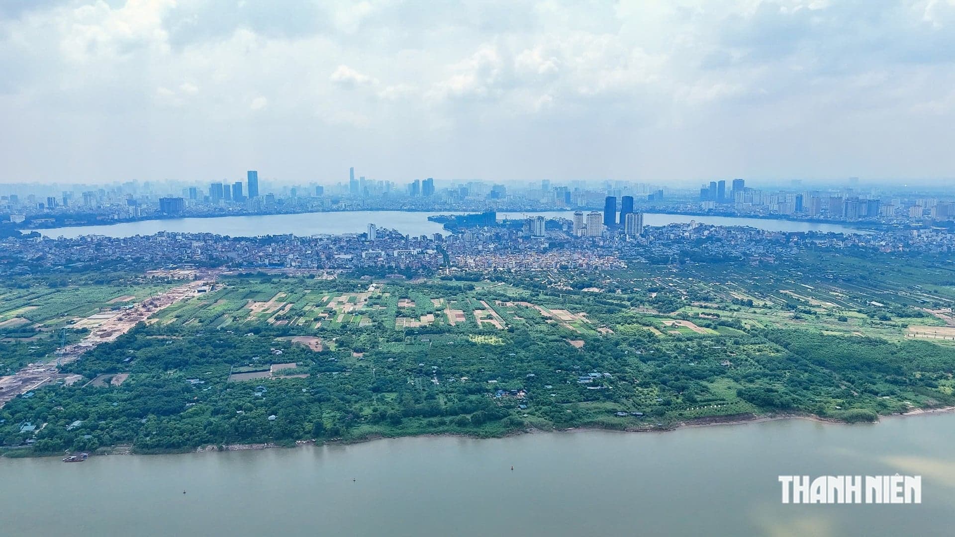
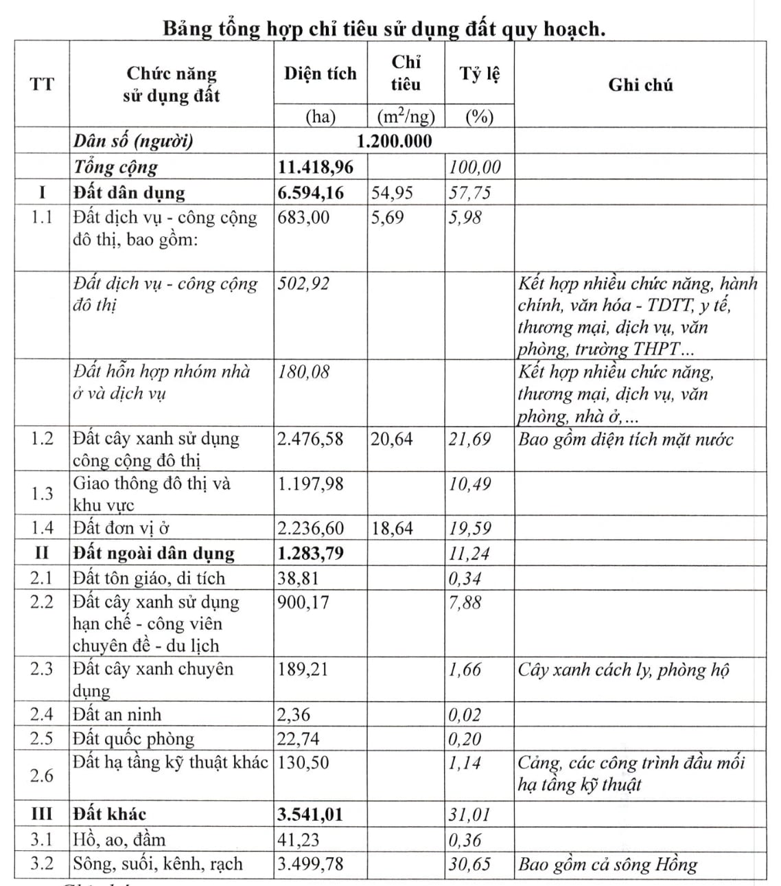
Hanoi approved revised detailed planning at a 1:5,000 scale for the urban area along the Red River. The plan covers the section between Hong Ha Bridge and Me So Bridge and an area of more than 11,400 ha. Almost 6,600 ha, or about 58%, will be urban-use land.
Vu Dai Thang, chairman of the Hanoi People's Committee, signed Decision No. 6075 approving the revised plan.
Population in the Red River area capped at 1.2 million
The planning area lies within 16 wards and communes: Thuong Cat, Dong Ngac, Phu Thuong, Hong Ha, Bo De, Long Bien, Linh Nam, O Dien, Me Linh, Thien Loc, Vinh Thanh, Dong Anh, Bat Trang, Thanh Tri, Nam Phu and Hong Van.
Of the more than 11,400 ha, nearly 6,600 ha will be urban-use land, about 1,300 ha will be non-urban-use land, and more than 3,500 ha will fall into other categories, including lakes, ponds, wetlands, rivers and streams, including the Red River.
Urban-use land includes public and urban services, public urban green space, urban and area roads, and residential units.
The projected population range is 800,000 to 1.2 million people. The figure will be used to calculate land needs and the maximum load on social and technical infrastructure. The specific population will depend on compliance with flood safety and dike requirements approved by the competent authorities.
Seven projects planned in the first phase of the Red River boulevard
The urban space will be organized in layers, with building heights decreasing toward the river.
Flood-prone areas will be placed next to the river. Beyond them will be partly flooded zones with parks, green space and squares. Areas less exposed to flooding will contain tourism services and low-rise structures that can be dismantled. The area next to the dike is planned for mixed-use functions, commerce, services, offices, housing, healthcare and education.
The urban structure will be linear, with a continuous longitudinal transport axis and intersecting roads. Bridges across the river will form the main cross-river links between centers and functional zones on both banks.
Urban development areas must meet flood-prevention requirements and follow the approved spatial plan.
The first phase of the Red River landscape boulevard includes seven projects: the boulevard on both banks, a public park in Phu Thuong Ward, a riverside park in Hong Ha Ward, an “urban living room” area, a resettlement area in Linh Nam Ward, a resettlement urban area in Long Bien Ward and a separate site-clearance project.
The second phase will include 11 remaining projects, including a new urban functional area with housing, public administrative buildings, commercial and service facilities.
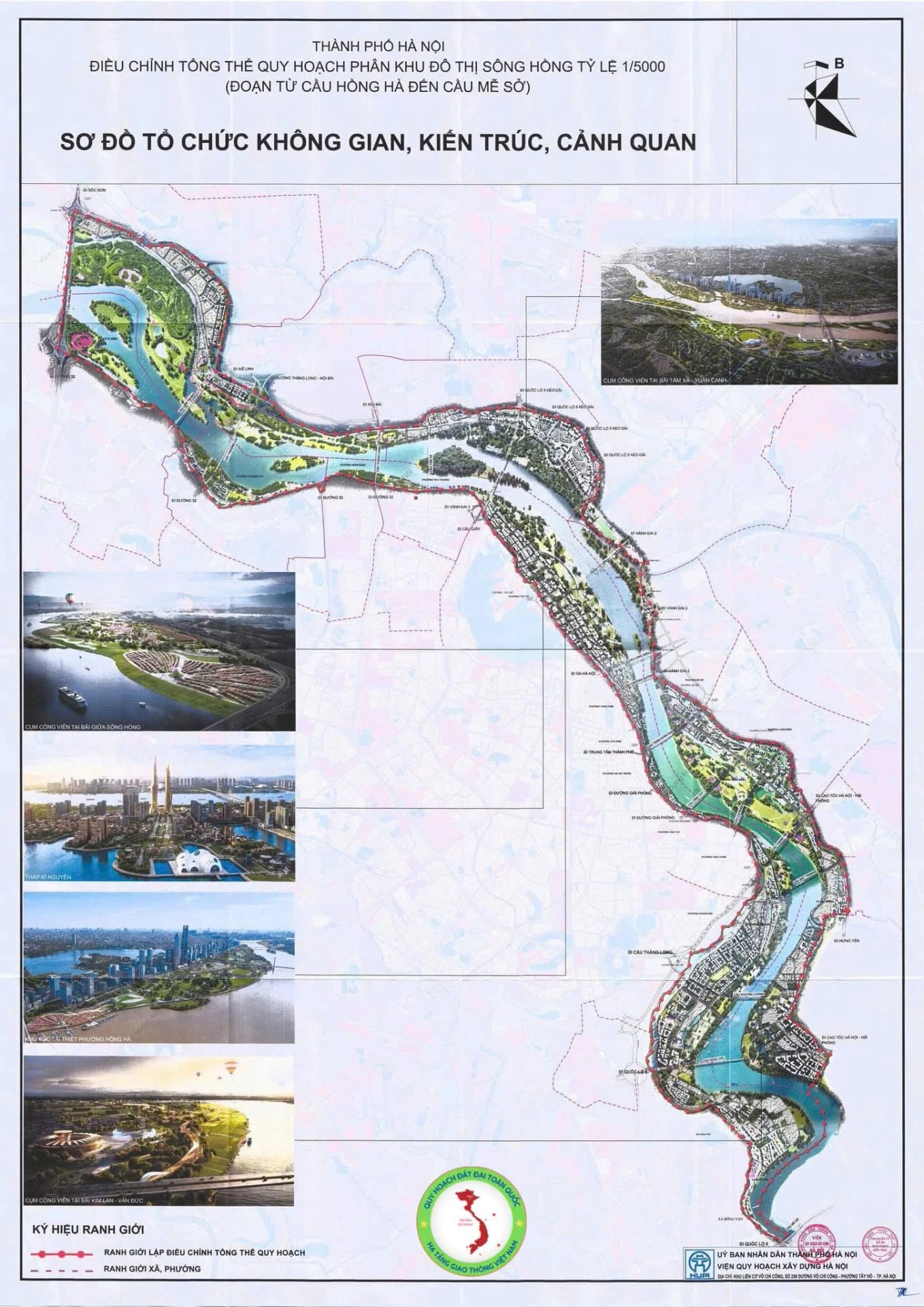
The two riverbanks will be organized into three sections
Under the revised plan, the two banks of the Red River will form a central green, cultural and landscape axis with water areas, riverbanks, parks, residential areas and urban zones connected by longitudinal roads, bridges and cross-river routes.
Section D1, from Hong Ha Bridge to Thang Long Bridge, is planned for ecological landscapes, nature conservation, village spaces, sports, research and visitor facilities, and new low-density urban areas.
High-rise buildings will be located in the Chu Phan and Trang Viet areas and around Thuong Cat Bridge. They will be linked to transport hubs including Thuong Cat Port and a railway depot.
Section D2, from Thang Long Bridge to Thanh Tri Bridge, is planned as a mixed-use, multifunctional area with cultural and arts centers, international trade and finance, tourism services, innovation facilities, and cultural and arts parks. It will also include new urban areas, resettlement areas and multi-purpose urban districts.
On the right bank, the “urban living room” will combine urban parks, the renewal of existing residential areas and multifunctional spaces. Several major public and cultural buildings will serve as landmarks for the right bank.
The left bank is planned for modern urban functions, including public buildings and different types of housing that fit the overall landscape.
Urban parks will run along both banks and the mid-river island. The area is also expected to include a landmark tower linked to the West Lake–Co Loa axis.
Section D3, from Thanh Tri Bridge to Me So Bridge, is planned for urban parks and a specialized ecological recreation park with visitor activities. Urban functions will be linked to cargo and passenger ports and inland-waterway berths serving tourism.
Hanoi says the architectural composition of the entire area must follow the overall development plan. The “urban living room” area is identified as a major feature and a strategic landmark for the capital.
Sources: Thanh Niên